OS Explorer map 375, Isle of Mull East: Craignure – I own this map, and have visited it before starting this blog. Visited again for this post 31st March 2018.
My previous post, about map 374, had me and the Dearest Progenitors, on a trip to our cottage on Harris, come to Mull for a couple of days. That post, though, had a gap in it – we arrived on Mull at Tobermory on the 31st March, but then left that map to go to our hotel. The post resumed the next day (1st April), when we drove back to the northern end of Mull for a day of sightseeing. Now it’s time to fill in that gap!
So the hotel we were staying in for two nights was on the Ardmeanach peninsula, the middle of Mull’s three westward-facing peninsulas. I repeat the map from my last post, which features our hotel marked with a helpful red cross:

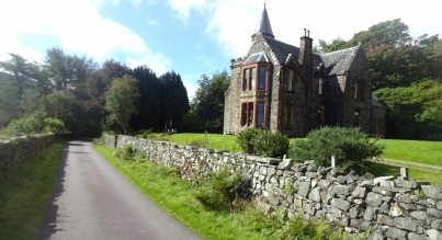
So yes, it was about 5pm (actually 16:44 according to my Google Maps timeline, which tracks my phone) when we left Tobermory to drive to our hotel. The drive down to Ardmeanach along the B8035 from Salen is just wonderfully scenic, as I could remember from my previous time on Mull (on which see below). However, I didn’t take any pictures on that road just then, so wait just a moment, patient reader. Arriving at our hotel, were met by its pleasant owner who looked like a mad scientist, and checked in; we then lazed around for a bit before coming down for dinner.
The next day, our plan was to drive around the north of Mull, as was described in my previous post. To get there, though, we had to go back up the B8035, during which trip we stopped the car a couple of times to admire the view, since it is thoroughly worth admiring!
")
")
The road was also surprisingly busy; when finding a parking spot, we did have to dodge the many parked cars of hikers presumably up on Ben More for the day.

It was also here that we recorded a silly video of ourselves wishing a happy birthday to my cousin’s young son, whose birthday it was. [1]
We then left this map area for all of the shenanigans described in my last post, and then passed through it again on the way back to the hotel in the afternoon, when we had to stop for a bit while these two finished their business:

We got back to our hotel in need of food since we’d missed lunch, and sought out some sausage rolls in their little café and tearoom, where we were rewarded not only with the food but the company of a pleasant dog and cat. It was then back to the hotel for another couple of hours of lazing about before dinner and bed! It was during this afternoon that I did something I very rarely do and, rather than one of the books I had with me, read a book that was in the hotel room – it was rather enjoyable actually, the comical memories of a Cumbrian farmer.
The next day, the 2nd April, would be the day when we’d be returning home. We therefore arose in time to drive to Craignure and get the ferry to Oban, after which we drove to Glasgow airport, stopping only for lunch at a hotel on Loch Lomond, and were home by the evening.
Previous visits
I have been to Mull once before, in summer 2016, on my trip travelling between Lindisfarne and Iona with my Cambridge friends, about half of which on foot – that was the trip we called the Holy Island Trek, which has featured on this blog several times before.
We arrived on Mull on the 5th of September, as we were nearing the end of our trip. We had walked from Lindisfarne to Melrose along St Cuthbert’s Way, and then explored Arran and various parts of Kintyre and Argyll, partly in the car, and partly on foot. The plan for Mull, though, was to walk the whole way, about 38 miles, from the ferry port at Craignure to Fionnphort, from where the little ferry goes across to Iona.
We turned up at Craignure, arriving on Mull and in this map area, in the evening from Oban, after a reasonably relaxed day where we’d visited a castle and done some shopping. Now, frequent readers will remember the particular delight of my writing about the Holy Island Trek – on that trip we kept our Annal, a collaborative diary of events, from which I am thus able to quote:
Our campsite on Mull was very close to the ferry port. Fridges, microwaves and real warming rooms containing log stoves were just some of the delights on offer, although we were slightly concerned for those camped closer to the seas edge than the storm door. […] We were soon able to pitch up and eat a supper of tortellini and carbonara-and-cheese sauce – owing to an accidental purchase of one carbonara and one cheese sauce pot, rather than two of the former.
The entry for that day ends like almost every other: “Finally, we went to the pub”. In this case, however, there is an extra marginal note: “We saw sheep getting on the ferry”. Alas, they were in a vehicle driven by a farmer, rather than freely entering as foot passengers, which would have been much more exciting.
The next day was to be a walking day. The map below shows the actual GPS tracks of our walking for the next three days, until we reached Iona. The ferry is a blue dotted arrow, and our campsite for the first two nights is the red cross.

You can see that we didn’t actually end up walking all the way, instead skipping about six miles at the start. We had originally planned this whole trip, you see, as an entirely walked one, where we would not have a car. The original plan then had us do a first day from the campsite to Lochbuie, which is in the middle of what ended up being our first (blue) day, and camp the next night there. However, having a car meant that these plans would have to change, since I would always have to go ahead to the end of the day’s walk in the car, then get the bus back so we could walk to the car – we therefore had to start and end on bus routes, and there is no bus service to Lochbuie. For this reason, we started six miles later, at the start of the road that goes to Lochbuie, where there is a bus stop, in order to be able to also end that day on the bus-served main road. (We did intend to go back and do the first six miles on the last day, as that day’s walking was very short, but in the end we didn’t bother.)
So yes, off we set in the morning in the car. I dropped Vesper and Millicent off at the end of the Lochbuie road and then drove on to the end of our day’s walk, the Kinloch crossroads, according to the bus timetable. There, I parked the car, and awaited the bus. I had a vaguely entertaining experience when it arrived, because, it turned out, I was the first person the driver had ever picked up at that stop. She made the comment that she should give me a free ticket or something. She didn’t though.
In any case, we were soon reassembled and started walking along the minor road that leads to Lochbuie.
We soon came to an obstacle in the form of a field full of peacocks. The road didn’t go through the field or anything; it just ran next to it, but Vesper has a severe dislike of large birds, peacocks especially – fortunately we got past quietly creeping.
There was a monument to Victoria’s Diamond Jubliee which [Millicent] stated to have been unwisely made of metal, and although we failed to find a stone circle, we did see Moy Castle and the uninspiring Lochbuie House. We talked about our childhood interests, with [Vesper] telling us about her cow phase. [A gloss here reads “more of a lifelong obsession”.]

Soon, we left Lochbuie to walk through the most wilderness we’d now get on the trip, over Glen Byre back to the main road where [I] had left Hilda [i.e. my car]. We began our ascent with some difficulty, as it seemed the mystical Pathmaker had here attempted to save money with a 2-in-1 path and stream. Moving onto the path that would lead us over the glen, we found that it could rarely decide on its existence. Soon enough, we stopped for lunch on a large rock, and soon moved on again. The steep climb up Glen Byre was wonderfully rewarded with views down the glen to the sea.

That glen was wonderful – deserted, leading to the sea, just beautiful. It was also probably the furthest from civilisation we got on the trip – about four miles from the nearest road isn’t terribly far to be, and pretty pathetic for the most we managed on a hundred-plus-mile walking trip across Scotland, but we were mostly in reasonably populated (or at least, not entirely unpopulated) areas, partly since we’d chosen the route to visit interesting historical sites along the way.

From the top of the pass, we were rewarded with our first glimpse of our journey’s final destination: Iona!
Our descent from the pass down to the road and our car required passing through a dense and rather prickly pine forest – it had long firebreaks that were marked on the map, so we had thought we’d be able to find our way through reasonably easily, especially with our GPS device, but in the end we did have to push through some very dense springy branches and wet our feet in some rather boggy burns before we were through.
")
")
")
")
The extent to which we were in the wildernss was revealed by the excitement we experienced at seeing first a sheep, then a signpost and some vehicle tracks. By this time, [Vesper] and [I] had thoroughly wet boots. However, [Millicent] had been using the blessed stick of St Máel Rubha and miraculously, each timehis boot entered water, it emerged inviolate.
That last paragraph of the annal refers to the stick that Millicent was walking with, which he had, way back in Argyll, dipped in a holy well to St Máel Rubha. Some good-natured pseudo-hagiographical riffing about its miraculous properties was therefore just right for our mock-medieval annal – after we wrote it, a mildly shoddy Latin translation of those lines has been added interlinearly for good measure! (I will admit that was me…)
uir Dei [Millicens] ambulabat cum baculum sancti Maelrubhae, et cum posuerit [Millicens] pedem suum in aquam, ex aqua reddidit uero siccus!
We eventually arrived back at the car, and drove back to the same campsite as we’d stayed at the night before.
There [I] cooked noodles while [Millicent] and [Vesper] did washing, hampered by a non-functional dryer. [My] Special Drink of orange juice, lemonade and lime cordial was rechristened Theodore’s Thirst-Quencher [after Theodore of Tarsus, Archbishop of Canterbury 668-690]. And then we did not go to the pub, instead to the lounge tent.
And so the day was done! The next day’s walking was almost entirely in map 373 of the Ross of Mull, so I shall leave that all for when I post about that map!

[1] Indeed, his birthday is on the 1st April, April Fool’s Day. He was born in 2011, back when I was at school, and my parents unusually both came to collect me from school together that day in the car, telling me that my cousin had had her baby, and so we were going straight over there to see them. Especially since the baby was several weeks early, I came to the natural conclusion that this was a a joke, given the date, and so didn’t believe them for a good twenty minutes.
